A runners perspective


I hope this blog is of use/interest to walkers, runners and cyclists living in or intending to visit Scotland. Most of my entries below are described as long-distance runs - just because that's currently what I enjoy doing...

Friday 12 September 2014

Grampian Weekend Day 2: Inverey to Spittal

Distance: 19.5 miles (31km) Ascent/Descent: 1000m/1020m  
Start/Finish: Inverey to Spittal o Glenshee
Terrain: 70% gravel/surfaced road, 30% Pathless 
Transport: Hmmm, tricky.  Bus to Spittal from Blairgowrie.  Bus to Braemar from Aberdeen.
Route: Route Map/Profile  
Day 2 of 2: Previous Day

Summary

A fine cross-country route from Braemar/Inverey to Spittal of Glenshee, some shameless Munro bagging involved (for the views, honest!)

 Blog

If anyone remembers the first edition of that revolution-starting book, "The Munros", there was a particular page which had always grabbed my imagination, particularly back in the days when I liked to involve the bike as a means to get to less-travelled routes up hills.  Its the page for An Socach I think, and it shows a scene of a nice flat-floored grassy glen enclosed by brown hills with a twin-rutted track winding without obsticle towards the great outdoors.  I was 16 years old when I first acknowledged it as a place I wanted to pedal through, and to this day still hadn't been there.


Looking back over Inverey to Deeside
Sunday morning in Braemar, still, grey, mild, and the nearby summits clear.  My dad and I had decided on a stroll up Glen Ey - starting at the little carpark at Inverey a few miles W of Braemar.  Finally I'd get to see and experience that place from the book, albeit by foot not mountain-bike, and by chance, within teasing reach of here was my final 'unbagged' munro in this part of the grampians!  "Carn Bhac".  I do still tick them off, more as a side-project these days.

Being the last day of August the heather was in full spendour, much of Deeside splashed with purple.  The track up Glen Ey gave easy progress from the car park and quickly we were enclosed by hills and leaving the domain of roads and cars behind.  After nearly four gentle miles we crossed a wooden-slat bridge, turned a corner and the scene got even better.  Now beneath the gable-end of Creag an Fhuathais, the grey sky submitted to a band of blue, the Ey Burn pacified into mirror-like pools breached occasionaly by trout jumping for flies, then the sun seemed to find us, there was not even a breeze, and my dad had found his slice of heaven.

"Why don't you run on to Spittal and I'll pick you up there?" he'd asked a few minutes earlier. 

My dad watches trout in the mirror-like Ey Burn
I wasn't expecting that.  It was a very tempting offer, but I'd done 25 miles at pace yesterday over the White Mounth, and other than a cheeky wee run up and down Carn Bhac, I had nothing planned for today and was't suitably equipped.  When we reached those trout pools with the sky clearing and warmth from the sun beaming down as if to pay us back for yesterday, I'd decided I'd take him up on his offer and go fo it.  Legs feeling fresh considering, the weather looked promising, I had confindence in my knowledge of the geography beyond this glen so why not?

I'm so grateful for this suggestion - within the first 500 yards of jogging up the track towards the ruined lodge at the head of the glen, my favourite tunes playing, the pace increased and I was pretty much bounding, excited by the prospect of a great journey ahead, God knows why running in these places brings so much pleasure, even in the drab conditions yesterday.  I've never quite felt the same euphoria when walking or pedalling a bike but for some reason the act of running and also having the fitness to run up pathless hillsides mile after mile is for me just the best feeling.  Especially when its a place far from the sight and noise of over-crowded places and traffic.
The flat top of Carn Bhac (looking SW to Beinn a' Ghlo)

After leaving my dad I only saw 2 couples up on the hills, and at a distance - never an encounter.  As I toiled up the gentle screes beaneath Carn Bhac's final "lump", I half expected to rise into turbulent air and need to put a jacket on.  Instead, it was calm, warm and sunny up by the cairn, and the visibility across Scotland, particularly Westwards, was magnificent.  To the SW was Carn nan Gabhar - the nearest peak of Beinn a' Ghlo - looking shapely and prominent, and to the North the Cairngorms appeared more as a single solid Plateau rather than individual mountains.  I'm so glad I came up here instead of cutting over watersheds directly to Glen Taitenaich - Munro bagging mentality has its moments.

A heavenly mile of easy running followed as I headed towards Beinn Lutharn Mhor.  Then it got messy, because the col was large and riddled with peat hags, and by the time I'd weaved and contoured around these to reach the base of the Beinn, my legs had lost their zing.  I took this as a cue to sit down amongst the heather, enjoy some water and cereal bars, soak up the sunshine for a few minutes whilst trying to pick my route up the fairly imposing wall of scree ahead of me.  One thing was decided - I wouldn't be running up it!
Looking back to Carn Bhac from B.L.Mhor
In fact it wasn't even just a walk - the ascent turned into more of a crawl, using all-fours as I took a line towards the Eastern top of the Beinn.  It wasn't quite as steep as it looked though, and gave a nice view of a lochan in the mountain's North Corrie that I hadn't known was there.

Once on the summit the running was fantastically easy - a gentle rise took me to the true summit cairn, followed by an easy descent S towards the next col where I turned more SE picking up a feint but very enjoyable deer track along the Northern contours of Mam nan Carn, and once clear of that summit I could drop down to Loch nan Eun.  I'd vague recollections of doing this particular bit before, from an epic day about 6 years ago when I'd cycled up from Blair and ran the circuit of Munros around the loch, escaping back down Glean Taitneach to get back on the bike, having a horrible "bonk" and nearly passing-out on the A93.

Loch nan Eun
My dad and I had roughly agreed to liase at the Spittal about 5pm, and although I had quite a few miles still to do they were all downhill and mostly easy, it wasn't even 2pm.  Surprisingly I had a mobile signal before dropping to the Loch so sent a message to my dad saying I'd probably be there 3:30pm.  Then I picked up the path around the loch around to where it spills into a waterfall bound for Taitneach, and once there I just sat down in the warm sunshine for a nice long break and marvelled at the landcape around, watching 100 or more deer make a rising traverse of the hillside.

Looking down Gleann Taitneach, the route off the hills to the Spittal
Gleann Taitneach is a fine place to linger, but today I was really enjoying my running and so refreshed from the break I made my way very quickly down the track for several miles to the Spittal of Glenshee.  Presently here was the saddening sight of the recently burned-down Spittal Hotel.  Many happy memories have either started or finished in that place.

Previous Day

Grampian Weekend Day 1: Lochnagar and Glen Muick

Distance: 24.7 miles (40km) Ascent/Descent: 1110m/1250m 
Start/Finish: Braemar to Ballater Terrain: 75% gravel/surfaced road, 25% Good high-elevation trail Transport: Good Stagecoach bus service between Braemar & Ballater 
Route: Route Map/Profile
Day 1 of 2: Next Day


Summary
 
A great non-technical cross-country route from Braemar to Ballater via Lochnagar and Glen Muick. Relative to other blog entries this was a very short day, in fact less than 3 hours 50 for me as I treated it as a workout at times! But if you look at the profile there's not much up and down other than the initial up and final down, and its all so runnable. Having said that, a fair amount of time is spent 1000m up on an exposed plateau, no place to crock an ankle, so carrying emergency clothes/blanket is common sense (as is "just taking the bus instead" for some).

Blog

I've never been a fan of the phase "there's no such thing as bad weather, just bad clothing". Fair enough for a survivalist. But generally I'm out on the hills by choice, and when you can't see shit and your picnic's soggy a multitude of breathable layers doesn't turn the sky blue. However, this is not a moan about how I spent 8 miles around 1000m+ on the White Mounth wishing it would clear up so I could see fantastic views over the Grampians, Cairngorms and down into Deeside. I'd been up here and seen it before, allbeit 20 years ago. Today I had a blast along an excellent and relatively easy trail with a sharp wind helping me along, and the weather just added to the sense of wildness and probably kept Lochnagar relatively peaceful for a weekend in August. Me & my dad were up in Braemar - he was looking to do a walk around Ballater as he hasn't done much over that way before. So I settled for running there, wherever he'd parked the car, and do a jolly cruise of Lochnagar and Glen Muick.

Looking back towards Braemar from the start of Glen Callater
During a break in the rain, and starting from outside the Fife Arms Hotel, I headed up the single-track road past the golf course, retracing the route I did when going Blairgowrie to Braemar via Jocks Road - finishing in darkness! Today I almost missed the little bridge over the River Cluanie after a couple miles, already in a running trance! Once found, the bridge let me get over to the base of the landy track up to Loch Callater. I reminisced about the last time I'd been here when it was Winter and dusk, and I remembered how much I'd enjoyed that. Today it was nice in a different way - seeing it in daylight, even with the rain starting to build up again, the sun made an effort and cast a low rainbow in the glen behind me. On approaching the loch I should have continued through the gate past the lodge to pick up the path to the White Mounth, instead I continued on to the shore, a nice enough detour, but it did mean a tough heather-avoiding ascent straight up the hillside to get myself on the path again which seemed to have already gained a fair bit of height where I finally joined it.

Looking over Loch Callater towards line of Jock's Road
From here it was easy angled on a well-maintained trail but lots of boulders on it to keep the eyes from looking at the view over the loch. The path curves away from the glen, dipping momentarily before starting to climb onto the Mounth proper. So I layered up a bit, gloves and hat went on, then proceeded to enter the clouds. After a few minutes and on reaching a stone-wall with rusty fence posts, I left the path to reach the summit of Carn an t-Sagairt Mòr, a fairly pointless exercise in these conditions other than an easy summit to bag since the path went so close.

Looking back down the contouring trail (L. Callater hidden below)

I got the full brunt of the wind up on the top, thankfully blowing from the side, but it meant running with one eye as I headed down the other side to find my path again. A mountain-bike-pusher appeared from the mist ahead, he was bent into the wind and probably about ready for a nice landrover track by now. I briefly dropped into a hole in the clouds before rising back up onto the plateau proper, gradients remaining easy until a final but brief pull up Lochnagar to Cac Carn Mòr, then its a case of turning more N to reach the marginally higher summit of Cac Carn Beag and its trig-point-topped Tor. Enroute to this I played chicken with a charging black lab, it wanted to join me on my run back off this soggy windswept lump.

More cheek-freezing wind as I retraced a route back to the larger cairn and then beyond to continue SE then E over the plateau, tracing the edge of the cliffs on a good path which after a mile dropped fantastically down the large scree, slab-by-slab, out of the cloud and back to a more friendly-looking world lit with patches of sun. The loch of "Lochnagar" was now visible to the left and an impressively conical lump ahead which I couldn't be arsed climbing. I was soon "layering-down" to a T-shirt again, picking up a landrover track that rises up from the top of Glen Muick.

Dropping quickly from Lochnagar via a dirt road
From here it was an easy and very fast run NE down the glen along an excellent car-free track, just a couple miles of road at the end before arriving at Ballater feeling invigorated. My dad had come off the hill only 30minutes before, having had a soaking up the hills followed by a cup of tea and scone. The weather forecast promised better for tomorrow, so we decided we'd maybe do a walk...

A fine cycling/running track down the length of Glen Muick
Next Day (Sunday)

Monday 26 May 2014

Edinburgh to England

Distance: 67 miles (108km) Ascent/Descent: 1380m/1360m  
Start/Finish: Edinburgh - Berwick upon Tweed 
Terrain: First 35miles flat and easy, bikepath/established trail, then it gets bumpy. Short sections of thick vegetation (R. Tyne)   
Transport: train stations at start/end.  Perrymans Buses link Eyemouth, Cockburnspath, Dunbar, Berwick, Edinburgh  
Route: Map Part 1 Map Part 2

Summary
  
A long day, but a fun project to find a route with interest between Edinburgh and England.  Nice rural and coastal bits with hills, but unlike me you should be able to enjoy a prevailing tailwind.  Unless as I suspect global warming has "broken" this!  If you want to break the 70mile barrier, start in central Edinburgh and follow the bikepath around Holyrood Park into Brunstane, part of the John Muir Way and clear on the OS map.

Blog


Brunstane Path - from Brunstane Station
Thanks to Sharon I was setting of from Brunstane Station on the East edge of Edinburgh at 6am - it was an early start just to ensure there'd be enough time for food and drinks in Berwick this evening - possibly the best tasting food and drinks ever!  The sky was a dirty grey and there was drizzle in the air, but it was also mild and calm and I'd had enough coffee so wasn't grumbling.  I felt pretty fit and confident that I'd enjoy most the journey - especially as it was all new trails to me, excluding a few miles along the Edinburgh Marathon route at the start.

Down the recently-surfaced Brunstane Burn Path towards the coast and into Musselburgh, thank God for the garage there as the public loos were locked at this early hour and I was in pain.  Which chocolate bars to buy for the right to use the facilities is probably the quickest decision I'll ever make.

I continued much more comfortably following arrows and signs and police cones prepared for the Edinburgh Marathon tomorrow (I never got my entry in this year - possibly over-compensating for that today!) then cut off along the John Muir Way which heads East between the wierd landscape of Ash Lagoons and Musselburgh Race Course, through Portobello and around the decommissioned coal power station,  Those chimneys are coming down as the facility get refitted with gas-turbines!  This was the first of two concrete walkways around powerstations that featured on today's route. There were some nice bits too I promise!


Re-joining the marathon route, which gets much nicer as it leaves Cockenzie behind and parallels Seton Rocks/Sands, I followed a path along a quiet winding road through hawthorns, about the 15 and 21 mile points of the race. I turned right up a lane by the Golf Course and then into Longniddry Dean, then out onto the road at the top and along pavement for a mile to Longniddry Station where Sharon was waiting patiently with some replacement water for the bottles. 

About 10 very easy miles done, fairly urban, was looking forward to getting into the countryside a bit more...

Looking back along Longniddry - Haddington Railway Bike Path
I entered Longniddry station and crossed the tracks via the footbridge, picking up the railway bikepath on the other side which would swing off SE towards Haddington.  This was more like it!  Again very easy running being an old railway path, it climbed gently through hawthorns with views back NW over wheat fields, as far as Fife's Lomond Hills across the Firth of Forth.  I followed the bike-route signs under the A1 and eventually down through town along West Road with its large houses, through the square and onto the bridge over the Scottish River Tyne, where Sharon was parked with some salt n vinegar crisps ready!  The idea was that next time I'd see her, she'd be warmed-up and ready to run after enjoying a nice lunch in a warm deli/cafe in Cockburnspath that didn't actually exist and was a figment of my badly eroded memory from being there to start running the Southern Upland Way over 3 years ago!  Oops.
 
Abbey Bridge over River Tyne
River Tyne
From Haddington, I'd pretty much be following the River Tyne to the coast near Dunbar, thanks to a right-of-way called the "River Tyne Walkway".  To get onto this, I had to continue East after the bridge until reaching a park after a cemetry on the left, where I turned left down a lane to a bridge back over the river again, then sharply right to pick up an excellent bikepath for about 1.5 miles.
 

The bikepath finishes at Abbey Bridge, from where a much more rustic riverside path continues via a style beneath one of the bridge's arches.  At this time of year (late Spring) the route was already fairly overgrown in patches, so my pace slowed accordingly, and I was glad to be wearing calf-guards as there were a few nettles hiding in there!  Otherwise it was fine to run, with care, I'm not sure what it would be like in July/August, or if it gets any maintenance.

The river is quite modest, the scene was very rural now, if you ignored the A1 a couple of fields away, and it all felt very English already!  Literally through the hamlet of Sandy's Mill, ncluding across someone's garden via gates with signs that ask you to respect the owner's privacy, i.e., don't loiter.  Then past Hailes Castle and back under the A1 into the tidy town of East Linton.  

Hailes Castle across the River Tyne
Mouth of the Scottish River Tyne
Bellhaven Bay
After consulting a map at what felt like the centre of the village, I followed the High Street then turned Right onto Preston Road joining the John Muir Way for the second time today.  A JMW sign pointed me off this back to the River Tyne and a footbridge across it.  From here the good signposting of the JMW took me down towards and then onto an Embankment, which to my surprise turned out to be part of the East Coast of Scotland!  On its other side was the estuarine mouth of the Tyne.  The JMW took a lumpy route along the S shore of the estuary before swinging away more E through trees and back out towards Belhaven.  In spite of the wind which was wearing me a bit, I tried to stay true to the JMW along the outside of the golf course, but erosion blocked the route past the Club House so I was forced S onto "Back Road" into Dunbar.  No great loss, I'm not that keen on flying golf balls as they can make holes-in-one. (Sorry).


It was almost sunny in Dunbar, and it was busy.  Maybe too busy for a thirsty runner who'd run 30 miles.  I grabbed myself a couple bottles of powerade and got on my way, again needing my map to find the path out of town onto the coast - just so easy to just keep following the road instead especially when a bit tired.


Leaving Dunbar, about to brave more golf balls
Barns Ness
Thus followed some more golf-ball dodging, hemmed between a 2ft cliff to the beach and the out-of-bounds markers, with occasional signs reminding you that you were entering the flight path of golf balls. Joy. 

I sped up and kept my head low, glad when the fairways were behind and I turned a coastal corner away from that wind for half a mile.  Only to re-enter more golf-ball avoidance territory and then a large opencast lime quarry.  You may have gathered this wasn't my favourite bit of the route.  Although not grumpy, I probably hadn't eaten enough to be enjoying my day's chosen activity at this feeling wasn't helped by the non-prevailing NE wind tilting me a bit from the sea!  Thankfully at Barns Ness, with its big white lighthouse, the coast swings more SE and I really felt the difference, especially enjoying the shelter of the dunes there.  Lovely white-sand beaches followed, spoiled only by the blight of Torness Nuclear Powerstation.  And so I was routed onto another concrete nature trail around a powerstation, where I got to run above the sea-water cooling inlets and the site of an infamous jellyfish incident.

A bit overgrown heading towards Cockburnspath
 Things rapidly improved South down into Thorntonloch Caravan Park, where I was immediately routed onto the lovely beach (head for the wet sand ASAP!), then back inland to gain a footbridge, eventually down to the very start of the cliffs that would be major feature of the rest of the coast down to Berwick!  As soon as the N frontier of the cliff appears, the JMW climbs up onto it, and then follows some fairly over-grown and barely-used trail squashed between cliff and fields for a few miles. To make up for the underfoot toughness, the coastal views ahead were becoming more inspiring!  Even the layer of gloom cutting out the tops of the higher cliffs Southwards just complemented the scene.

A dramatic, brief scenery change as the path veered inland then dropped through trees into "the Linn" which felt like a rainforest environment with its ferns, dark greens, waterfall and canopy instead of sky.  At the bottom of this was some tiresome shingle beach, pretty, but tiresome.  


I had missed the track cutting into the next Dean, and ended up pointlessly crossing a burn, only to recross it, pull myself up a steep muddy slope where others had clearly made the same mistake, and found the much more formal route back inland and into an impressive gorge beneath the old and new "Dunglass Bridges".  To think I've probably been over these bridges a dozen times on the A1 without noticing!  After crossing beneath the bridges onto the old A1, a sign for "Cockburnspath/Southern Upland Way" directed me away from my planned route along the road.  It looked much more inviting, a little farm track continuing up the dean, it was uphill but so nice I didn't care.  Just before the steepest part another sign directed me left out onto what felt like an ancient track across a field, then skirting some woods to gain Cockburnspath from the N, where poor Sharon was still doing hill reps to stay warm having taken a bus there from Berwick in her running gear and finding that the Deli/Cafe I'd imagined was actually a Post Office with a Hot-drink Vending Machine.  On the bright side I had arrived bang on time!
Dunglass (High contrast)
Lucy arrived 5 minutes after me on a bus from Dunbar - funnily enough the first and last time I'd been in Cockburnspath before was with Lucy when we were exploring the Southern Upland Way.

Just over 40 miles done, about 27 to go, and having sat down to eat a muffin, half a packet of cheesy watsits and a vending-machine-made cappacino (with powdered-milk-crutons), I was finding it difficult to keep up with the girls as we headed downhill right past the start of the southern-upland-way (mistake) and under the A1 by Cove.  So we just followed the road down to Pease Bay Caravan Park, momentarily joining the SUW before following the road a little South then taking the steps North which were well marked as being part of the "Berwickshire Coastal Trail".  Which was immediately excellent!  Up onto the cliffs proper now, 50m above the North Sea, then back inland to pick up a track winding gently down a vale of bracken and bluebells, then taken right gently uphill to and through a farm and out into fields.

The signposts were pretty good, when they were present and you actually saw them.  A couple times along this very hilly coastal section, we felt a bit lost and travelled of course.  Okay the general rule of keep the sea on your left applies a bit, but its always more comfortable to be on the official route.  So yeah a bit of map-faffing on my part, we did eventually concede to the need to climb fairly steeply South on damp divotted ground, climb a fence into a field of curious bullocks, and thankfully re-attain the waymarkers E, eventually higher into the murk and onto a single-track road about 220m above sea-level, the highest point of the journey today.  This was Dowlaw Road, and it was a shame we were up in the mist because I'm sure the views would have been pretty good.  It certainly had a remote feel, being so exposed and well away from the busy A1.  At Dowlaw Farm we ignored the option of visiting "Fast Castle" provided by a fingerpost, instead continuing more directly for the pub at Berwick.


Heading towards St. Abbs Head
The closer to St. Abbs Head we got, the more up-and-down the route became, and also the more pretty.  My favourite section of trail was actually one of these ridiculous downs-and-ups, Lucy had pointed the fingerpost on the far-side of a deep dell that we would first drop down into almost to the level of the sea from about 130m up then back to 150m on the other side (Westerside Dean I think).  There were more people around as we came down to Mire Loch.  The route ignores the easy option and took us up onto St. Abbs Head proper, then down to the sea and dramatically back up again now facing South with a great view over St. Abbs and miles beyond.  The hills really seemed to have sorted my legs out and I was loving this section!  And it was all new territory for us, although Lucy had walked the dog in the area before.

At St. Abbs, we made our way down to a cafe right next to the harbour for some drinks (and a big slab of malteseer cake that I'd strongly reccommend) before continuing South to the surfing hotspot of Coldingham Bay.  After another short climb over a low headland we were onto a nice secluded, grassy cove for a bit then some easier cliff-top running took us quickly into the top of Eyemouth, quite a metropolis after the last 25 miles.

 
St. Abbs from the North
 We had to go around the harbour, over a metal footbridge and up steps onto a road through a golf course, turning left down a trail nearly opposite the club house, leading back to the tops of the cliffs.  This is where it started to rain, and the air seemed to cool.  We were nearly heading due S so at least the wind was behind, which did make a difference.  A lot of this was beside a stone wall, eventually we dropped down into a place called Burnmouth, had to consult the map to find that we needed to go down a very steep and slimy tarmac road to Lower Burnmouth and its harbour.  I recall mentioning how much of a bastard that brae would be to cycle up, as it happens there's a bike race up it each May!

Lower Burnmouth Harbour
After dropping so far back down to the sea, it felt inenvitable that we'd just be going back up again fairly soon.  We weren't disappointed.  Back up a dean to the level of the railway, then contouring left along a track, eventually path, soon sandwiched between railway embankment and mini hilltops upon the cliffs.  A few trains went by, and we thought about how next time we were on the East Coast line we could look down at this track and remember the day's adventure!  With the damp and the long distance in the legs, we were starting to count down the miles to the pub.  "3.8miles" answered the geek with the mobile application.

At Marshall Meadows Caravan Park we missed the path back upon the cliff-top and ended up at a dead-end of cut-grass surrounded by stone wall and railway.  After some very soggy nettle-bashing (low point of the day) we found the narrow path again, along the top of the cliffs, and soon the industrial estate marking the Northern frontier of Berwick was in view, not too far away.  Then the housing estate.  Yet teasingly the clifftops veered away, curving around what's marked on the map as Magdalene Fields.  The trail was a bit rough and our shoes laden with water now, it really had become beer-o-clock.  Thankfully on arriving at the Caravan Park, we could finally head up a track, around the leisure centre and up a lane direct to the train station, quickly grab some drier gear and head straight for the bar in the Castle Inn.  Mission accomplished.  Those beers and crisps tasted very fine.  6:30pm arrival I think, pretty chuffed with that as it meant plenty time in the pub to refuel and hydrate.


Saturday 18 January 2014

Speyside Way - Part 1

Distance: 50miles (80km) Ascent/Descent: 1260m/1070m  
Start/Finish: Buckie to Grantown on Spey  
Terrain: Mostly easy river-side rail-trail, some long stretches of tarmac, boggy hillside for 7 miles after Cragganmore 
Transport: train to Elgin then good early bus service to Buckie, train and  citylink bus services at Aviemore Route Map1/2 | Route Map2/2


Summary

There's plenty great info on the Speyside Way online, but I struggled to find many blogs covering exploration of the whole thing.  Most blogs that I did find were runners race reports from the Speyside Way Race, which covers the original 36mile length of the route (before it got extended to Aviemore and Buckie).  Being low level and never too far from civilisation it feels like a good Winter option.  The public transport at either end worked out well, allowing a 7am start from Buckie in spite of catching the train to Elgin late on Friday and staying the night there (plenty buses, and not so many trains South from Aviemore in the afternoon/evening).

Blog

It's still dark, not long past 7am on a Saturday morning, three of us running briskly along a frosty railway path directly towards a full moon, sound of waves crashing against the nearby shore, and the whole day ahead to look forward to - just brilliant!  For one day at least, we had become part of those annoying morning people who get up and "do stuff" before everyone else wakes up.  (And then post about it on Facebook).

We left the square in Buckie and with some success followed the waymarkers along the coast, squashed between the road and shingle.  It was dark and I'd never been here before so can't really describe what we were missing, but we weren't missing lots of puddles and stones!

Daylight was imminent as we entered the woods near the mouth of the River Spey - this bit of singletrack was a blast, then out of the trees and past the old empty hotel and along tarmac to the wildlife centre.  Dolphins are a common sight from here.  This morning we just had to make do with a cloudy sunrise and the sounds of breakers somewhere behind the dunes.

From here we were finally heading more S along the bank of the river, starting the journey upstream towards the Aviemore and the Cairngorm National Park.  At first the scene was very flat, farmtrack beside fields of stubble and muddy woodland, then after a few miles of this we were running under the A96 road bridge and into a park on the edge of Fochabers, where the first of many forested hills roll up above the Spey.  The river was always closeby on our right.
Earth Pillars Viewpoint (after Fochabers)

You don't see much of Fochabers from the Speyside Way itself, which heads away from the river along a burn then routes you back S past and around the school to join a singetrack tarmac road.  The next few miles of the route are along this, which from the few other blogs I've read can be a disappointment for walkers, but for runners/cyclists its pleasant enough I thought - climbing immediately up onto hillside, traffic rare, views opening out.  On top of the first rise is a sign for "the Earth Pillars", and curiosity got the better of us so we followed the narrow path into the trees in search of them.  What we found was a nice viewpoint above the river, but no pillars.  It was only after returning to the Speyside Way road and following it down into a deep gully and steeply up the otherside that we understood.  Looking back across to where we'd been, the steep hillside itself was composed of pillars of earth rising above the Spey.  The road here would make for great cycling - challenging but pretty.  Today we had to be very careful with black ice.  Knowing we still had a long journey ahead of us, we took a brief walking break on this hill (its a great excuse) then enjoyed some relaxing downhill tarmac through thick pine forest before emerging onto open hillside that allowed inspiring views over the Spey and to the higher hills cloaked in haze beyond.  That's where we were heading!

The road drops down to Boat o' Brig, an impressive structure, but rather than crossing the river here the route zig-zags offroad up into the trees and so begins the climb onto the shoulders of Beinn Aigan.  I really enjoyed this bit - again other blogs have understandably groaned about the forestry and lack of views, but there was something really nice about the track up through the trees here, really peaceful running country.  And after climbing to 200m altitude we were rewarded with another just-off-trail viewpoint back downstream towards the coast - looking very distant now!

The forest track starts descending, occasionally threatening to climb again but generally allowing downhill coasting, back off the sides of Beinn Aigan to meet another country road by the river.  This is followed to the A94 just N of Craigellachie, where a sign said "Bar" and I so started talking about Guinness, and would continue doing so for the next 25 miles.

Here we made our rendezvous with Norrie, who would join us for an out-and-back run along the Speyside Way (he ended up clocking a marathon!).  Again the way doesn't really enter town, but I needed some water or sports drink so went in search for some, ending up at a garage on the road to Dufftown before I found any so owed an apology to the others by the time I rushed back down.

Looking back to the coast from Ben Aigan (not picnic time of year though)
So now there were four of us heading along the bank of the Spey along old railway trail, the river always near.  Again Aberlour was bypassed closeby on the left.  It was really nice, easy running along the rail path, very enjoyable even on tiring legs.  The Spey wound its way through the hills, quite closed-in at times, and the scene was of damp winter colours (reds, golds, browns of the trees and bracken, green fields with sheep, grey river and sky!). 

I can't describe the speyside way without mentioning distilleries, we passed a fair few, some right against the path.  There were also "preserved" railway stations that I recognised from photographs - Blacksboat being one.  Surprisingly not very many other people about along the way today, I guess it is early January, but I can only remember seeing two groups of cyclists, and I can't recall seeing any backpackers!  We had been very lucky with the weather.  When I'd planned this weeks ago I had kind of hoped for a crisp winters' day with a coating of snow, but what we had was fine - a cool cloudy day and a light wind from the S, which we were sheltered from in the valley and trees most of the time.


After what seemed like miles and miles along leafy railway path by the river, we crossed the Spey and arrived at Cragganmore where Fionna's dad was waiting to take her back home after a 34mile morning's run!  Dad's are great.  We took photos, said goodbyes, then it was just me, Carrie and Norrie for the next bit, heading W along the river.  Norrie had ran more than he planned but was fair chuffed when he realised after another kilometer he'd have covered half a marathon, which meant a marathon by the time he got back to his car at Craigellachie!  So shortly he was saying goodbye to and it was just two of us left to continue the journey along the Spey.
Bridge by Cragganmore

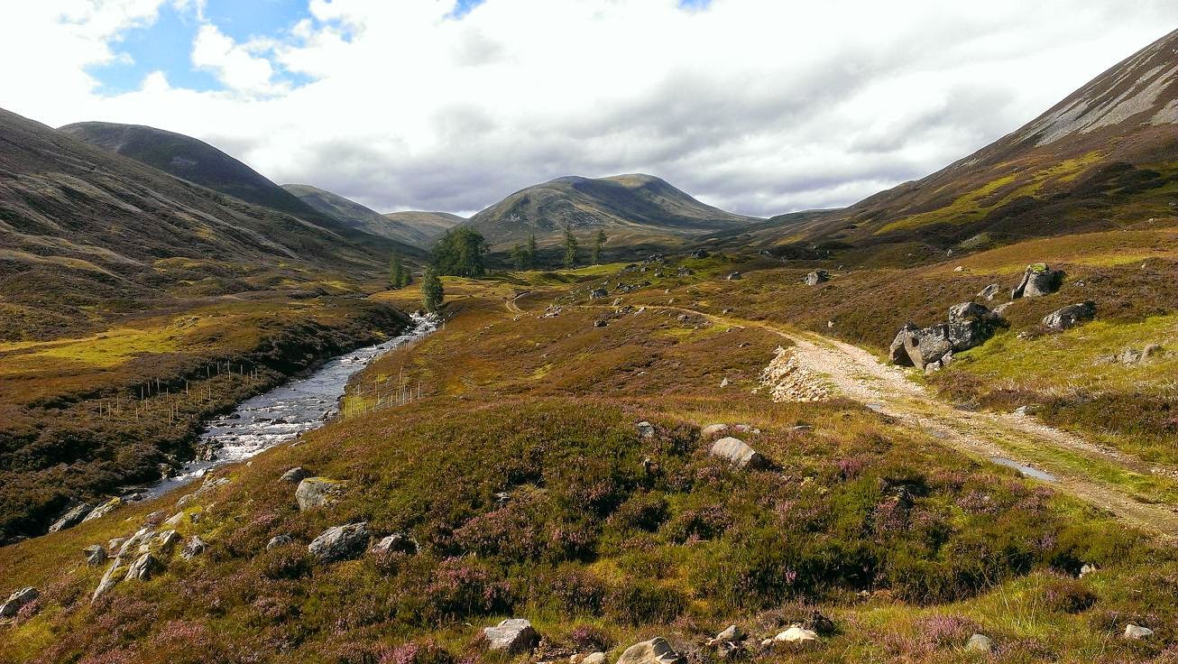
Its not long after Cragganmore where the scenery changes quite a bit - mostly because the route departs the railway and river bank and heads S up onto boggy hillside, and so the enclosed river-side is left behind and quickly we found ourselves surrounded by an open landscape of rolling heathery hills, the Cairngorm National Park was getting very close!  Again I found it quite inspiring - the flat farmlands and coast felt a long way away now.

This was the start of what's described as the "toughest" section of the way.  Its all relative of course - the Speyside Way is generally very easy, but after running 36 miles the  boggy ups and downs along hillsides are never going to feel like a stroll in the park!  The route climbs to cross the A95 road then climbs some more up through birch and onto muddy forest track.  I commented to Carrie how chuffed I was that we had got this far in daylight.  We'd covered the ground a lot quicker than I anticipated having assumed we'd be in darkness now, navigating by headtorch, which other than the obvious "training benefit" really defeats the most of the purpose of doing this stuff, for me anyway.  Neither of us had been along the Speyside way before (well the bit as far as Nethy Bridge anyway) which was much of the appeal of doing this route.

We were now traversing the NW slopes of the Hills of Cromdale, the Spey lost somewhere below on our right, the hilltops lost above grey murk above on our left.  And then the drizzle started.  The next few miles were up and down, forest track interspersed with sections of mud, tufty grass, bog, often enclosed by fences, lots of gates, lots of stepping stones which were hazardous due to a coating of icy moss, and more often than not I opted for the safer if unpleasant cold-wet-feet option!

Some more gates, fences, mud.  Yes I was tired now, and I had enjoyed my day but by this point I was counting down the kilometers to a warm hotel in Grantown and never mind one pint of guinness I was now thinking more a "sesh" of guinness.  Maybe the bar would have some Cairngorm Brewery beers too.  Carrie was after fish an chips, then beer.  It all felt like fantasy here on the cold damp hillsides.

"10km to go!" I announced, somewhere on a steep uphill section which entered thick spruce forest ahead.  I had my phone with the route on it so generally knew exactly how far was left.  We'd recently just passed a stone plaque with the Cairngorm National Park logo on it.  And it was still daylight - although the sky was darkening very, very slowly.  And having not eaten much today I was feeling the cold a bit more now!

I knew we were on the "penultimate" hill of the day before dropping back down to the Spey, the A95 and the railway path again.  When we got there, it really did feel like the final stretch, just 3 miles to town, and mostly easy going.  Back to flat fields, with the village of Cromdale on our left.  We crossed the Spey for the final time today via a tarmac road, and then onto a really nice woodland path which took us into Anagach Woods - pine trees and carpet of heather.  We clocked the "50mile" mark somewhere in here.  It was near-dark in the woods, but we could still just about manage without headtorches, and soon I was able to announce "Civilisation!  I can see a street light!"

We emerged from the woods at a Speyside Way info sign at the bottom of a lane, and agreed to stop running there.  The hotel was found, eventually, and I made contact with the folks who were up exploring the area too, and so it wasn't too long before we were enjoying the beer, food, warm clothes and great feeling of satisfaction in the pub.